
Usseaux: Hiking Routes, Murals and Historical Heritage
Accommodation in Usseaux
Nature Park and Hiking Routes
Usseaux is one of the municipalities in the Orsiera Rocciavrè Nature Park. The “Verso i pascoli di montagna d’Usseaux” route leads through the village of Usseaux, characterized by numerous murals, to remote high-altitude hamlets on open, scenic meadows. This selection of trails therefore begins with the transition from the village landscape to the higher-altitude countryside.
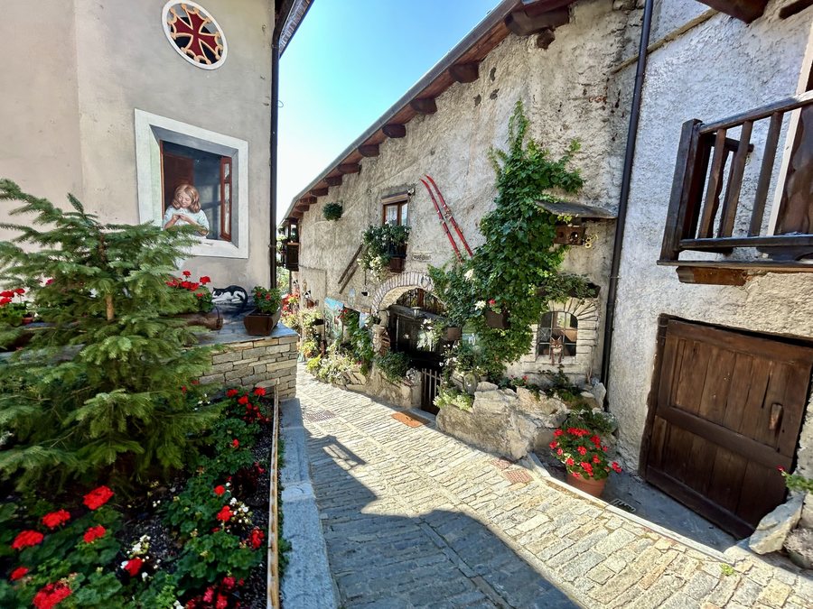 File:Usseaux - Comune di Usseaux - (2025-09-17) (1).jpeg
Photo: Olgierd Rudak via Wikimedia Commons, CC BY-SA 4.0
File:Usseaux - Comune di Usseaux - (2025-09-17) (1).jpeg
Photo: Olgierd Rudak via Wikimedia Commons, CC BY-SA 4.0
Alpine Lakes, Forests and High Pastures
The “03 Laghi dell’Albergian” route is a classic high-altitude hike to alpine lakes, summer flowers and distinctive mountain peaks. The “05 Sentieri Larici-Cembreta” route focuses on a circular hike through larch and Swiss stone pine forests; animal tracks can also be found in the woods. The “09 Balboutet: Alpe Assietta” route leads through a green high valley with extensive high pastures, streams and impressive panoramic views.
Pastures, Forests and Historic Buildings
The “11 Pian dell’Alpe Pequerel – Il Forte Serre-Marie” route is an easy circular hike through pastures and forests to military forts from the 18th and 19th centuries, as well as to an avalanche-protection structure. Montagne d’Usseaux is also known as Borgata Giurdan and lies along the Sentiero del Plaisentif long-distance hiking trail. The routes thus refer to both natural features and historical points of interest, without conflating their respective courses or character.
Practical Information for the Sentieri Larici-Cembreta Route
If you are planning the “05 Sentieri Larici-Cembreta” route, parking is available along the Strada Comunale dell’Inverso near the bridge over the Torrente Chisone. A bus stop on the SP23r is 150 meters from the starting point of the route. This information specifically concerns this trail and its starting point.
Culture and Local Heritage
The parish church of Usseaux dates from the 17th century. The Mulino Canton is well preserved and still operational. The Forte del Colle delle Finestre dates from 1891. Together with the murals and the military forts located along the “11 Pian dell’Alpe Pequerel – Il Forte Serre-Marie” route, these represent different historical themes: religious architecture, a preserved mill building and military structures from different periods.
Bread and Cheese in Usseaux
The local Pan fournià bread is baked for at least one hour in a wood-fired oven after a long dough fermentation. The Sentiero del Plaisentif long-distance hiking trail has the eponymous Plaisentif cheese, also called formaggio delle viole, as its thematic focus. Tastings of the formaggio delle viole cheese are offered in Usseaux. In addition, Plaisentif cheese is served with local bread in Usseaux. Thus, the regional specialties focus both on the preparation of the bread and on the long-distance trail’s signature cheese.
The Strada dell’Assietta
The Strada dell’Assietta is an ancient military road from the 18th century. It runs at an altitude of over 2,000 meters along a route approximately 40 kilometers long and connects the municipality of Usseaux with Sestriere and Alta Val Susa.
Other destinations: Sestriere, Susa, Valprato Soana, Bardonecchia, Pragelato, Villar Pellice, Claviere, Fenestrelle
To the main travel overview: Turin.

_(1).jpeg)