
Ottlar: Hiking, Views and Village History
Accommodation in Ottlar
Ottlar offers several opportunities to explore the Upland landscape on foot or by bicycle. For planning your day, short, easy circular trails are available as well as longer routes connecting to the landscape around Lake Diemelsee. The natural experience is complemented by the Dommelturm, a Kneipp footbath facility, a shelter with panoramic views and the St. Margaret’s Church in the village centre.
Key facts on the topic
- The OT1 circular trail is 3.8 kilometres long and leads as an easy circular hiking trail from the hiking information board in the village centre back to the starting point.
- The OT2 circular trail around the Dommelturm is 2.7 kilometres long. The start and finish are at the Dommel hiking car park.
- From the Dommelturm, you can enjoy wide-ranging views across Diemelsee Nature Park and the Sauerland mountains.
- The Diemelsteig passes through Ottlar and connects the village with the landscape around Lake Diemelsee.
- The OT4 circular trail starts in the village centre and follows the Uplandsteig for part of the way around the Hohe Egge.
- The Dommel is around 738 metres high and the highest mountain in the municipality of Diemelsee.
- Ottlar has a Kneipp footbath facility; around the Niegelscheid, a shelter with panoramic views also invites you to take a break.
Short trails for straightforward day planning
If you prefer a compact hike, you can choose between the two easy circular trails. At 3.8 kilometres, OT1 is the longer of the two designated loops and starts and ends at the hiking information board in the village centre. This makes it easy to incorporate the trail into a plan that takes the village centre into account as the starting and finishing point.
The 2.7-kilometre OT2 focuses on the area around the Dommelturm. Its start and finish are at the Dommel hiking car park. The different starting points are important for your preparations: Depending on which loop you choose, you should orient yourself by the hiking information board in the village centre or by the Dommel hiking car park.
After a tour, you can plan the Kneipp footbath facility in Ottlar as another local stop. This does not imply a specific length of stay or a particular order for visiting the destinations; you can decide for yourself how you would like to combine the hike with additional stops.
Views and longer routes
The Dommelturm is a distinctive destination for anyone wishing to combine a hike with a viewpoint. From there, the views extend across Diemelsee Nature Park and the Sauerland mountains. The Dommel itself is around 738 metres high and the highest mountain in the municipality of Diemelsee.
For longer connections, the Diemelsteig is a useful route to follow. It passes through Ottlar and connects the village with the landscape around Lake Diemelsee. The OT4 circular trail, by contrast, begins in the centre of Ottlar and follows the Uplandsteig for part of the way around the Hohe Egge. This allows you to choose between a local loop and a trail associated with a named long-distance route.
There is also a basis for cycling tours: The quiet roads around Ottlar are suitable for varied rides through the Upland landscape and towards Lake Diemelsee. Around the Niegelscheid, a shelter with panoramic views invites you to take a break. When planning your day, check which route and rest stop suit the scope of your itinerary.
Village centre and St. Margaret’s Church
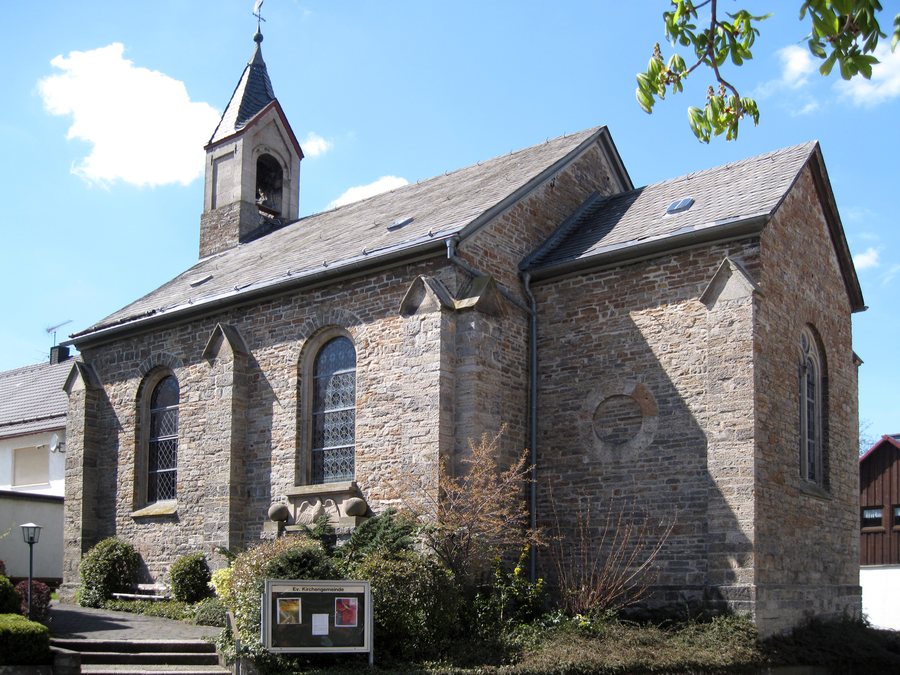
St. Margaret’s Church stands in the centre of Ottlar. The hall church in the round-arch style is dedicated to St. Margaret of Antioch. A chapel already stood at this site in 1537; the present church was consecrated in 1874. The building’s history also includes the organ, which was originally built for the Waldeck palace chapel and has stood in Ottlar since 1750.
If you are looking for accommodation in Ottlar, you can base your choice on your planned activities: A short loop, a viewpoint, a longer route connection or a cycling tour will result in different day plans. For further comparisons with nearby villages, you can also look at Heringhausen, Schweinsbühl and Stormbruch.
FAQ
Which circular trail is shorter?
The OT2 circular trail is 2.7 kilometres long. The OT1 circular trail is 3.8 kilometres long. Both trails are designated as easy circular hiking trails.
Where does the OT1 circular trail start and end?
The OT1 circular trail starts and ends at the hiking information board in the centre of Ottlar.
Where is the starting point of OT2?
The start and finish of the OT2 circular trail are at the Dommel hiking car park.
What views does the Dommelturm offer?
From the Dommelturm, you have wide-ranging views across Diemelsee Nature Park and the Sauerland mountains.
Which long-distance trail passes through Ottlar?
The Diemelsteig passes through Ottlar and connects the village with the landscape around Lake Diemelsee.
Is there an opportunity for cycling in Ottlar?
The quiet roads around Ottlar are suitable for varied cycling tours through the Upland landscape and towards Lake Diemelsee.
To the main travel overview: Diemelsee.

.JPG)