
Hohenberg an der Eger between Castle, Eger River and Porcelain
Accommodation in Hohenberg an der Eger
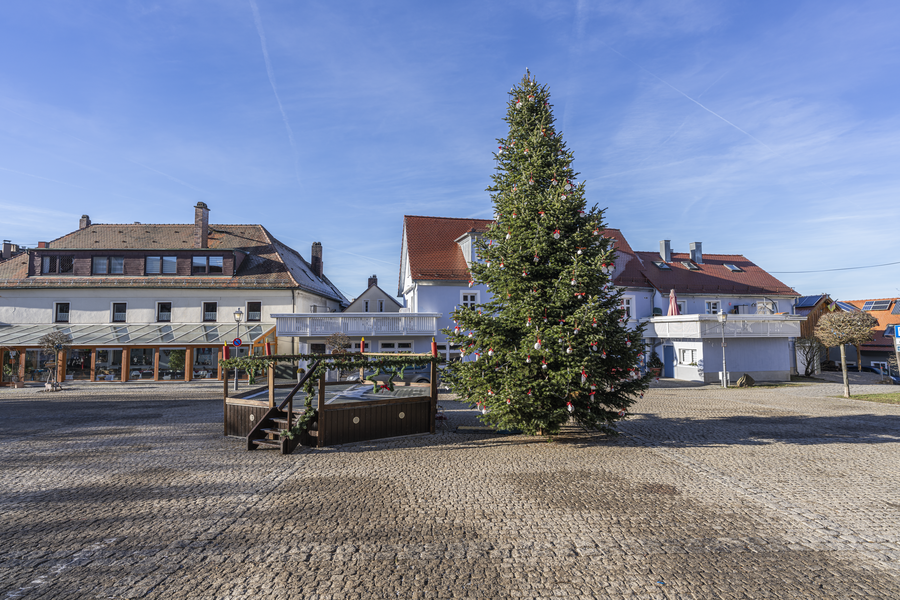 File:Burgplatz in Hohenberg an der Eger 20251227 HOF3782 RAW-Export.png
Photo: PantheraLeo1359531 via Wikimedia Commons, CC BY-SA 4.0
File:Burgplatz in Hohenberg an der Eger 20251227 HOF3782 RAW-Export.png
Photo: PantheraLeo1359531 via Wikimedia Commons, CC BY-SA 4.0
Hohenberg an der Eger combines a castle overlooking the town, the history of the regional porcelain industry and a landscape shaped by the Eger River. This gives you a wide range of excursion destinations: historic buildings, riverside paths, geological features and activities for different age groups are all part of the same local setting.
Castle, Church and Porcelain as Defining Themes
Hohenberg an der Eger Castle was built between 1170 and 1222 to protect an old trade route. This road led from the east via the town of Eger, now Cheb, past Hohenberg. Its history is therefore connected with an earlier transport route and explains an important historical reference point for the town.
The Church of St. Elisabeth is also part of the town's early history. It developed from a small chapel that belonged to the castle and was originally under the parish of Arzberg. A church visitation first mentioned it in 1508 as the “Chapel of the Blessed Virgin near Hohenberg Castle.” Inside, you will find an altar created by Marianne Wendt in 1949, a pulpit and a baptismal font made of reddish terracotta, as well as an oak winged altarpiece carved by Albert Sterr in 1952.
A second focus is porcelain. The Porzellanikon in Hohenberg an der Eger is housed in the former villa of Carl Magnus Hutschenreuther and presents the history of the regional porcelain industry. When visiting the factory outlet, you can also experience the special qualities of Dibbern porcelain at first hand. The “Milchhof” now houses the town archive and serves as a place of learning about Hohenberg's history.
Historical Traces in the Town and Riverside Landscape
The Confinhaus at Hohenberg's Hammer Mill lies at the transition between the town's history and its landscape. It is a former quarantine station dating from the late 18th century. The upper floor is timber-framed, while the gabled roof was altered at a later date. Hikers and cyclists who have used the border crossing at the Hammer Mill to travel to the Czech Republic since March 1, 1996, pass the Confinhaus before crossing the Eger bridge.
A 2.40-metre-high limestone bagpipe player sculpture has stood at the Eger bridge near Pfeiffer Mill since November 1963. It commemorates Bohemian musicians who travelled to Bavaria in summer during the 19th and early 20th centuries. The sculpture was designed by Oswald Hoffmann and made by Ludwig Deller. Another listed building can be found at Hirtengasse 2: the former forestry office, dated 1768, is a single-storey mansard half-hipped-roof building with rendered exterior surfaces, a half-timbered gable and a granite-framed doorway.
Eger River, Springs and Protected Landscape
On the German side, the Eger flows through Weißenstadt, Röslau, Marktleuthen and Hohenberg an der Eger. Its river course provides species-rich habitats with varying nutrient levels. The floodplains are rich in nutrients due to deposits from the river. Along the river, you therefore encounter not only connecting paths but also a landscape in which the watercourse, floodplains and natural habitats are closely linked.
The Carolinen Spring is located on the “Kuppelwiese” meadow in the “Kocherrangen” Nature Park, just a few metres from the Eger. It is a mineral spring with healing properties. From a car park, you can reach the spring in five minutes on foot via a forest road leading down into the Eger floodplain. Additional information boards, including ones from the Geopark, are located at the spring. Your visit can therefore combine a short walk with information about the natural environment and geology.
Heiligenberg is also a destination of significance for natural history: it is a protected geotope of high geoscientific value. To the west of the town, Steinberg also rises up. It is 653 metres high and lies in the Fichtel Mountains Nature Park. These two locations offer different accents between geological significance and experiencing the landscape.
Hiking Trails along the Eger
The “Kaiserweg” themed hiking trail begins in Hohenberg and runs along the Eger. Information boards cover the geology, natural environment and cultural history of the Eger Valley.
Circular Hiking Trail 1 follows the Eger downstream and returns to the castle square via a steep ascent through Kocherrangen Nature Park, with beautiful views of the valley. Circular Hiking Trail 7 has a different focus: it passes the Hirschsprung hydroelectric power station and then continues to the bridge towards Gut Blumenthal, which leads back to the opposite bank. After a turn at the bridge, this trail runs directly along the riverbank into the Weller Valley. The steep ascent on Trail 1 and the riverside sections of Trail 7 have different trail characteristics that you can take into account when planning your own outing.
Excursion Destinations for Different Generations
Sakura Activity Park opened in 2023. It offers play equipment for young children as well as fitness stations for senior citizens. The park is particularly impressive during the cherry blossom season in April. This gives the town a specific destination where children and older family members can each find activities suited to them.
The Fatima Chapel was built beneath an oak tree in 2005 and ceremonially consecrated that same year with a donated statue of Our Lady of Fatima. The Fatima prayer group meets on the 13th of every month for a service and prays the Rosary according to the requests of the Virgin Mary.
Getting There and Finding Your Way Around
Hohenberg an der Eger can be reached by train via Schirnding station and by car via the A 9 and A 93 federal motorways. At the destination, the attractions can be grouped by their character: the castle, St. Elisabeth, the Porzellanikon and the Milchhof represent history and culture; the Eger, Carolinen Spring, Heiligenberg and Steinberg represent the riverside landscape, geology and nature park; and the Kaiserweg together with Circular Hiking Trails 1 and 7 represent the connection between physical activity and the landscape.
To the main travel overview: Schirnding.

