
Schönberg in the Stubai Valley: Cycling Route and Local History
Accommodation in Schönberg in the Stubai Valley
Schönberg in the Stubai Valley lies where the Stubai Valley meets the Wipp Valley. The village is shaped by its distinctive settlement location, a cycling route officially opened in October 2025, and historic buildings. The central bus stop and a themed trail with a specified walking time and elevation gain can also help you find your way around. The various options make it easy to choose between local history, cycling and hiking.
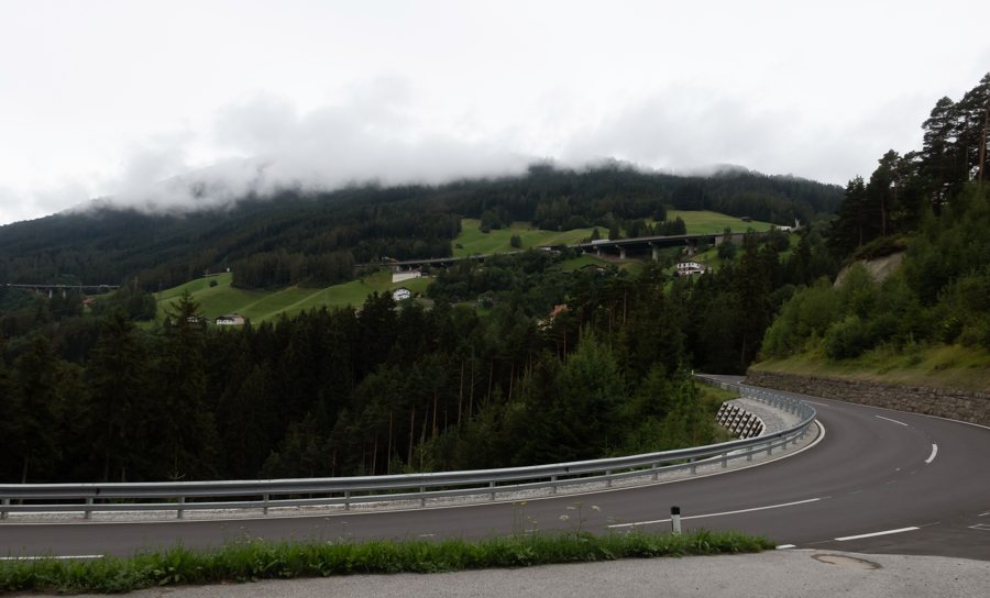 File:Schönberg im Stubaital, panorama vanaf Zeigerweg-Brenner Strasse IMG 0619 2019-07-29 12.54.jpg
Photo: Michielverbeek via Source, CC-BY-SA-4.0
Location, Village Character and Bus Connection
The municipality’s settlement area extends from Unterberg at 800 m to Gleins at 1,400 m. Schönberg is a clustered village, meaning a closely grouped settlement, and is surrounded on three sides by the Brenner Motorway, which crosses the Europabrücke. Ornate farmhouses shape the village’s appearance and give it a distinctive architectural character alongside its striking location.
The Schönberg i.St. Dorfmitte stop is served by bus routes 590–594 on the Innsbruck–Schönberg–Stubai Valley connection. It is worth checking routes and timetables before travelling to plan your specific journey. This lets you plan your connection using the named stop and group of routes, rather than assuming a departure time.
Cycling and Hiking
Stubai Cycle Route 19 starts in Schönberg and is signposted as far as Doadler Alm in Falbeson. The route also connects Schönberg with Neustift, Fulpmes, Telfes and Mieders. Its average gradient is five percent. The route description lists e-bikes, mountain bikes, road bikes, gravel bikes and balance bikes as suitable. Five percent is an average and does not describe the gradient of every individual section. When assessing a ride, you can therefore take into account both the average figure and the type of bicycle that suits you.
A hike is also described with specific time and elevation details: the 2025 Stubai Hiking Guide lists a family-friendly themed trail from Schönberg via Gleinser Weg to Alpengasthaus Gleinserhof. The walk takes around 1.5 hours and involves 335 metres of elevation gain. These details help you assess the hike in terms of time and elevation difference. This gives you different planning options: a signposted cycling connection between several villages, or a themed trail with a specified walking time and elevation gain.
Historic Buildings and the Holy Sepulchre
The Wittingwarte was built in Schönberg in 1890 as a wooden observation tower. It is a protected monument and was restored in 1994/95. The façade paintings on the Schöberlhof recall a building that once served as a post station. Andreas Hofer is also associated with Schönberg: the Tyrolean freedom fighter set up his headquarters in the village several times during the Battle of Bergisel.
The Holy Sepulchre was first erected in 1770 and is considered one of the most significant surviving works of art of its kind in Tyrol. The installation includes around 100 brightly coloured tomb spheres illuminated from behind, as well as candles. During Holy Week, numerous visitors make a pilgrimage to the parish church to view the Holy Sepulchre. If you plan a visit, check the parish’s latest notices beforehand.
Catholic Masses, parish services and liturgies of the Word are held in the parish church. As schedules may change, check the latest service notices before visiting. This helps you plan a church visit and view the Holy Sepulchre based on the most up-to-date information.
Discover more destinations: Fulpmes, Pfons, Tulfes, Mutters, Vals, Wattenberg, Mils bei Hall, Unterweg.
Back to the main travel overview: Innsbruck-Land.

