
Discover Fusch an der Glocknerstraße
Accommodation in Fusch an der Großglocknerstraße
Fusch an der Glocknerstraße has a small practice lift in the town center; you can reach larger ski areas by ski bus from the town. For a few practice runs, there is the lift in Fusch; Schmittenhöhe and Maiskogel are separate destinations for days on the slopes.
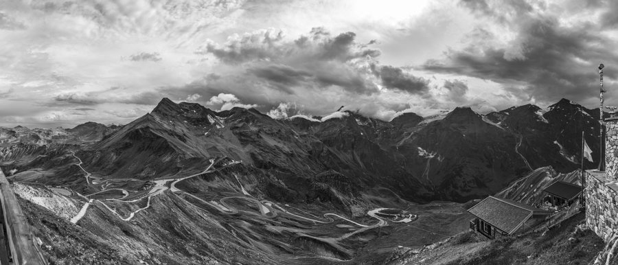 File:View from Edelweißspitze - Fusch an der Großglocknerstraße, Austria - August 6, 2026 01.jpg
Photo: Giorgio Galeotti via Source, CC-BY-SA-4.0
Skiing in Fusch and by ski bus
According to the tourism association, the practice lift is located directly behind the church. You can learn to ski there or enjoy a few relaxed turns. Check the seasonal operating status as well as the weather and snow conditions before your visit.
The ski bus runs from Bruck and Fusch directly to Schmittenhöhe in Zell am See, and another line takes guests to Maiskogel in Kaprun. The 3K K-ONNECTION links Kaprun town center with the Kitzsteinhorn. The tourism association describes the ski buses as free of charge and publishes timetables seasonally. Fusch therefore offers a local practice lift and connections to several areas, although those slopes are not part of the town itself.
The Großglockner High Alpine Road as a starting point
The Großglockner High Alpine Road begins in the Salzburg town of Fusch an der Glocknerstraße and leads to Heiligenblut am Großglockner on the Carinthian side. In the wider regional area, the road is 48 kilometers long; it climbs and descends through 36 hairpin bends to the Hochtor at an elevation of 2,504 meters. There are numerous viewpoints along the route.
To put the route in context, its starting point, destination, and notable places along the way are distinct reference points: Fusch lies at the Salzburg end of the road, Heiligenblut on its Carinthian side, and the Hochtor on the route between them. The viewpoints are also part of the route. This makes it possible to see the High Alpine Road as a defining feature of the region without equating its entire length with the town of Fusch.
Fusch Valley and Ferleiten Valley
Fusch Valley is 20 kilometers long. Ferleiten Valley lies in its upper reaches and is considered the most deeply cut glacial trough valley in the Eastern Alps. Its impressive head of the valley is framed by glacier-covered peaks over 3,000 meters high. A valley head is the end of a valley; here, the high, glaciated peaks shape the scenery.
These places offer different scales: Fusch Valley describes the larger valley area, while Ferleiten Valley refers to a particular section in its upper reaches. Visitors interested in the landscape will find a clear distinction between the course of the valley and the mountain-framed end of the side valley.
Adventure World and themed trails
The first adventure world after the Ferleiten/Fusch an der Glocknerstraße toll station includes a nature trail through the protected area with its larch meadows. Visitor facilities may be staffed seasonally, so check current conditions before your visit. The adventure world also features the special exhibition “The Highest Salzburgers: Part 1 – Fascination Mountain.” As the exhibition program may change, check the current offerings if you are planning to see it.
In Fusch, the “Hobagoas Legends Trail” circular route begins at the Ponyhof holiday village; it explores the legend of the Hobagoas. Nepomuk’s Path of the Senses starts at the tourist information office in Fusch and crosses a bridge directly over a waterfall. The two trails have different focuses: one explores a legend, while the other features a crossing over a waterfall.
History, the Fuscher Ache, and Bärenbad
The history of the area around the town can also be seen in a specific building: the Church of Saint Wolfgang in Bad Fusch was built around the year 1400. The course of the river and the fishing stretch provide further points of reference for the Fuscher Ache. The fishing stretch begins in Käfertal, runs through Ferleiten Valley and then passes through Fusch and Bruck before flowing into the Salzach. From its source in Käfertal to its mouth at the Salzach, the Fuscher Ache is about 28 kilometers long.
Bärenbad Fusch offers swimming as well as food and drinks on a sunny terrace. Operating hours and services may change seasonally, so check current conditions before your visit. You can consider this as a possible activity in its own right, separate from the road route, the themed trails, and the history of the church.
Discover more destinations: Sankt Georgen, Wald im Pinzgau, Hintermoos, Kaprun, Neukirchen am Großvenediger, Paßthurn, Gries im Pinzgau, Bramberg.
For the broader travel overview: Zell am See District (Pinzgau).

